This past July I got an excited call from my paddling partner, Bruce Kirkby, about joining me for the second of our two paddling trips to the Broughton Archipelago. “Hey wouldn’t it be cool if we just paddled back to your new house in Royston.” I knew this meant tackling the infamous Johnstone Strait, and trying to get down the east side of Vancouver Island in three and a half days, but it sounded like a fun, quick adventure and an opportunity to paddle and explore a new area of our coastline which I am always up for!

Johnston’s Challenge
I had my apprehensions about paddling south through Johnstone Strait. This is a massive, exposed body of water. Located in Kwakwaka’wakw traditional territory the strait is a 110km long channel along the north east coast of Vancouver Island and runs almost directly west to east from Queen Charlotte Strait in the north to the Discovery Islands on the southern end. It is a major navigation channel on the west coast of North America and the weather, to put it mildly, can be challenging, seductive one moment and terrifying the next. In the summer, the prevailing wind in Johnstone Strait is a westerly, often gale-force, funnelled by the mountains. The result can be a classic wind against current situation, heaping up the seas and creating, powerful dynamic conditions that are not only a significant threat to paddleboarders but to sailors and pleasure boaters alike.
Telegraph Cove to Robson Bight Ecological Reserve 14.5k
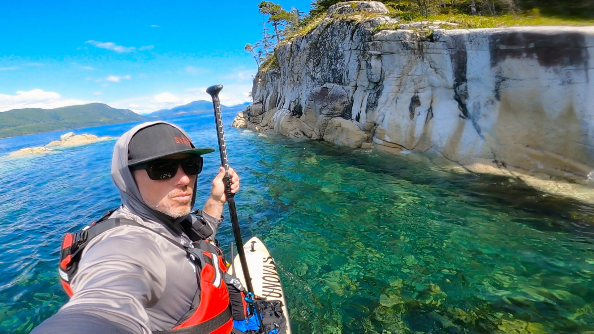
After wrapping up our five day Broughton trip and saying goodbye to an amazing group of ladies in the early afternoon, Bruce and I pounded back some food and quickly repacked our gear. Conditions in Johnston Strait were pretty good as we departed the quaint little ocean village of Telegraph Cove as the ebb current pulled us out and sucked us southward. We were off to a late start in the day but wanted to get as much mileage in as we could before the sun set. With the responsibility of guiding behind me we fell quietly into expedition pace as we entered the top end of the strait.
We made good time putting 14 km behind us as we approached the Robson Bight (Michael Bigg) Ecological Reserve. Robson Bight, on the northeast coast of Vancouver Island is known as the world’s most likely place to see Killer Whales in the wild. The primary role of the reserve is to provide a sanctuary for killer whales, their activities, and to protect their habitat. With that there are no boats, sea kayaks or paddleboarders allowed in this area and hiking to the Tsitika River watershed and estuary is prohibited. Bruce and I had to stay clear of this area and with darkness approaching and a light rain we set up our tent at north end of the reserve at the Robson Bight Border Camp.
Robson Bight Ecological Reserve to Hickey Point- 50KM

As we unzipped our tent “pea soup” fog greeted us this morning. Usually the fog would not pose much of a problem as we could just follow the shoreline south but since we had to totally avoid the reserve, I set a GPS co-ordinate on my watch that we would follow until we were clear of the area. The ebbing current out of Johnstone Strait slowed our pace to 4.5km/hr which was hard to tell as there were no reference points as everything was white. Keeping an ear out for boats and the blows of whales, we paddled in the fog for close to three hours before the veil was lifted revealing the rugged topography and rainforest covered slopes of Vancouver Island. I had to admit I was disappointed not being able to see Robson Bight and the unlogged Tsitika Estuary. Upon hitting our gps co-ordinate and clearing the reserve we changed our course back to the shoreline. I kept hoping that we would run into a pod of killer whales, the one potential sighting ended up being a group of kayakers off in the distance headed north. The weather began to improve as Bruce and I wrapped up a big day and found our second night campsite at Hickey Point. With camp set up camp, we dried our gear and with the sun on our face, we made a late afternoon coffee, Starbucks Via to be exact. Afternoon coffee is a small pleasure both Bruce and I enjoy and look forward to after a long grind. A Humpback Whale feeding right off our beach provided the afternoon show. I just love the feeling you get after a full day on the water, physically wrung out, leaving a feeling of peaceful calm. We fell asleep to the sound of lapping waves on our gravel beach.


Hickey Point to Cinque Islands – 60km

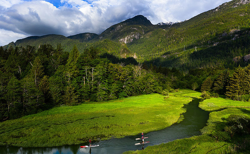
The infamous Johnstone Strait westerlies arrived while we slept and were our wakeup call as the winds buffeted our tent walls. We had a big day ahead of us so we downed a quick breakfast while watching two humpbacks rolling in the kelp beds just offshore. The sea state was challenging as strong shoreline currents combined with stiff westerlies that piled up swell creating unpredictable rebound effects. An hour of focused paddling brought us into the calm waters of Kelsey Bay where we stopped to see if we could find a seaside coffee shop. No luck, but we did chat with a friendly local, an old fisherman, who gave us some valuable information and points of interest about our route ahead. We rebounded and pushed south across the mouth of the Salmon River. We glided over crystal clear green waters with vast colourful beds of sea urchins and sea stars that quickly passed below our boards as strong tidal currents ferried us through Boat Passage. The highlight of day was an exhilarating tidal run that had us moving at a blistering pace of 12km/hr. We enjoyed the challenge and route finding as we looked for that “magic” line of efficiency, doing our best to hook into the ocean’s natural escalator. Similar to running a big river we used our river skills, draws, braces and edging to avoid whirlpools, boils, and back eddies. Having this skill set really aids in efficient coastal travel and allows you to take advantage of favourable conditions. 24km’s in two hours brought us to a major coastal transition zone, Chattam Point. Here the Vancouver Island shoreline abruptly changes course from south east to due south, this elbow can easily be seen on any map of the island. This was the highlight area of the whole trip for me, a stunning ecosystems and more like a portal that left the cooler, wetter and more rugged climate of the north island and presented a doorway into the warmer, calmer waters of Discovery Passage. Another hour of uneventful paddling had us landing on the picturesque Cinque Islands, a small chain of islands off the southwest shoreline of Sonora Island and characterized by Douglas Fir and Arbutus trees. Another long day was in the books and under a spectacular coastal sunset we devoured our freeze dried dinner and hit the sleeping bag early with thoughts of Seymour Narrows, our final barrier to Campbell River, on our minds.


Cinque Islands to Campbell River – 36km


Up before the sunrise, we double checked John Kimantis’s guide book over hot coffee and granola. Thank goodness for John’s guidedbooks, invaluable if you want to do any paddling on our coastline or if you are interested in planning a trip. His books and maps are filled with super valuable information, campsites, points of interest and detailed First Nations history for most of the coast. It feels in a way that John is with us on most of our coastal adventures and we can usually hear him whispering about the challenges and hazards our paddling route may provide. One of the most challenging hazards on the coast and the final crux of our journey was Seymour Narrows, a 5 km long section of the Discovery Passage between Quadra and Vancouver Island and known for its terrifying tidal currents. The area has claimed 114 lives and even Captain George Vancouver in 1791 described it as “one of the vilest stretches of water in the world.” Ripple Rock, an underwater mountain in the middle of the pass accounted for most of these deaths until April 5th, 1958 when the top of this underwater mountain was loaded with dynamite. The explosion that occurred, in hopes of clearing this obstacle, was the largest non nuclear detonation in the world. John’s sage advice was to hug the Quadra Island side of the narrows where you avoid most of the strong currents and could use a couple of bays to maneuver yourself into better position. The recommendation worked perfectly as Bruce and I hugged tight to the shoreline, making our way against the flood current while marvelling at the flowing fronds of Bull Kelp and revelling in the jam packed walls of intertidal life. We picked our way right to the light that marked the easterly entrance to the narrows where we pulled ashore, had lunch and waited for the tide to switch. From there it was easy sailing as we used the ebb current to push us all the way into Campbell River where we completed our journey down the Johnston, wrapping up 160km of travel in three and a half days. We gave gratitude to the weather and another safe journey. Thanks to Amber Turneau, my truck was waiting for us steps from where we landed. We loaded up the truck while quickly adjusting to the instant immersion of cars, people and business’s after days of remote paddling. With our physical, spiritual and emotional batteries charged, coffees in hand, we headed home.


If you are interested in a touring skills course to get you ready for your own expeditions or if you are ready to join us in the Broughton Archipelago then send an email and we can schedule a call. Reach out if you have any questions about our trip, gear or sections of our journey.
See you on the water, Norm

2 comments on “Expedition Report: Journey Down Johnston”
Thanks for sharing, what a wonderful trip.
Cheers and stay safe,
Thank you!